İz · Ride tracking
LIVE ON GOOGLE PLAYEvery ride leaves a trace.
Free route recording, from motorcycles to semi-trailers; your rides stay yours until you publish them.
- Antalya
- Muğla
01 · MOCK-UP
Try it in the browser
The mock-up runs on the app's own thresholds: pick a class, press Start, and the record writes itself.
The prototype below runs in Turkish — that is the interface it was built in. The app itself speaks Turkish, English and German.
İzlerim
Henüz sürüş kaydın yok
İlk sürüşünü kaydet; mesafen, süren ve rotan burada saklanır.
Sınıfı değiştirip aynı yolu yeniden kaydet; fark iki satır yan yana durunca okunur. Yol her seferinde 12,3 km.
Tarayıcıda çalışan bir maket — uygulamanın kendisi değil. Harita çizim, canlı değil; sayılar uygulamanın kendi eşiklerinden hesaplanıyor.
Sınıfı değiştirin — duraklama ve ortalama hız değişir.
- ÖRNEKLEME
- 5 m
- 2.249 konum yazılır
- DURAKLAMA EŞİĞİ
- 90 sn
- bu kadar duruştan sonra
- MAKUL ÜST SINIR
- 320 km/sa
- üstü kayda alınmaz
- Motosiklet90 sn
- Otomobil120 sn
- Karavan5 dk
- Kamyon10 dk
- TIR10 dk
02 · THE ROADS
Roads, and their traces.
Every route compiled source by source; every card shows where the road runs.
18 roads · 2,857 km · 220 stops
AKDENİZ
Antalya – Muğla Likya Kıyı Yolu
430 km
EGE
Çanakkale – İzmir
330 km
AKDENİZ
Tarsus – Silifke – Anamur Sahil Rotası
253 km
EGE
Bodrum – Datça
240 km
DOĞU KARADENİZ
Trabzon – Artvin Rotası
249 km
DOĞU KARADENİZ
Uzungöl – Ayder Yaylası Rotası
207 km
BATI KARADENİZ
Safranbolu – Amasra Yolu
96 km
İÇ ANADOLU
Nevşehir – Kayseri Rotası
84 km
AKDENİZ
Kaş – Kalkan Sahil Yolu
28 km
EGE
Assos (Behramkale) – Küçükkuyu Sahil Yolu
28 km
MARMARA
Kumbağ – Şarköy Ganos Kıyı Yolu
56 km
DOĞU ANADOLU
Erzurum – Yusufeli Çoruh Vadisi Yolu
146 km
GÜNEYDOĞU ANADOLU
Mardin – Hasankeyf Mezopotamya Yolu
126 km
DOĞU KARADENİZ
Artvin – Ardahan Sahara Geçidi Yolu
131 km
DOĞU KARADENİZ
Trabzon – Gümüşhane Eski Zigana Yolu
121 km
MARMARA
İznik Gölü Çevre Yolu
82 km
DOĞU ANADOLU
Ani – Ardahan Plato Yolu
214 km
MARMARA
Bursa – Uludağ Oteller Yolu
37 km
03 · BEND RECORD
A road's character is read from its geometry.
İz writes a bend record under every ride: heading change per kilometre, and one of four classes.
- THE WHOLE RIDE
- Curves37°/km
- CharacterFlowing
The record of the mock-up's Ankara ride; computed from a road's geometry, not from a ride recording.
Privacy is a feature
Publish nothing and nothing leaves.
Publish, and the ends stay behind.
TRY THE TRIM
The app picks the radius itself, between 400 and 700 m, on every publish; the slider exists only here.
01
No rankings.
02
Top speed is never published.
03
The recording stays on the device; publish nothing and nothing leaves.
04
Publish, and the ends are trimmed by 400–700 m — afresh on every publish.
05
The map key is not in the app.
A road is not a track. There is no leaderboard.
On public roads there is no ranking by time or speed — in no vehicle class, at no point.
Obeying traffic law is the rider's responsibility. Under no circumstances does İz encourage exceeding a speed limit, breaking a rule, or racing on a public road; content of that kind falls under moderation.
Why it was built this way, in the founder's own words; the full mechanics and commitments: how the privacy works
What comes out
The Distance Plate.
Publishing to followers
The client side is written, but publishing is not open on the server side yet.
Year in İz
The trace you left this year.
The year's rides come out on one card; a year without rides builds no table.
The rider side
No leaderboard. Riders, though.
İz's social side is not a score table.
- EXPLORE
- The whole shelf opens inside the app, offline; it is the same for everyone.
- INVITE
- You invite with a code or a QR; the invite card carries your own record.
Publishing to followers is written on the app side; publishing is not open on the server side yet.
SOON
Badges for contribution, not for speed.
We want the rider who shares a road first, verifies a route, or fills in what was missing to be the one who shows up.
- ROADS SHAREDHow many new roads you shared.
- ROUTES PROPOSEDHow many routes you proposed to Keşfet.
- FACTS VERIFIEDHow many stops, notes and warnings you confirmed.
Speed, records and rankings enter no badge.
The real app
Turn the key. The rest happens on its own.
All four from the app itself: My rides, the ride record, the weather plate, sharing.
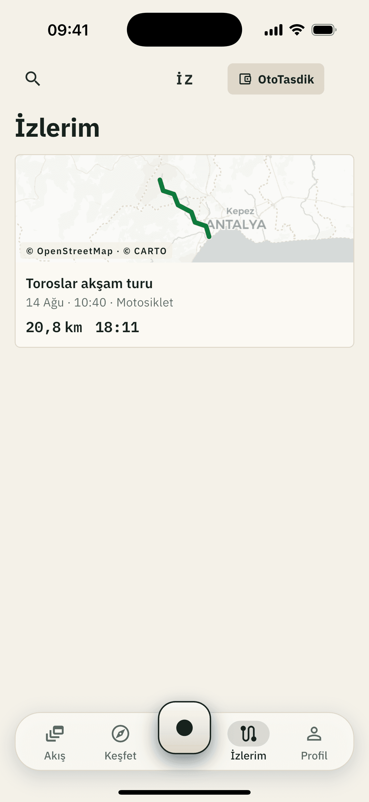
Turn the key; recording starts.
My rides — everything recorded
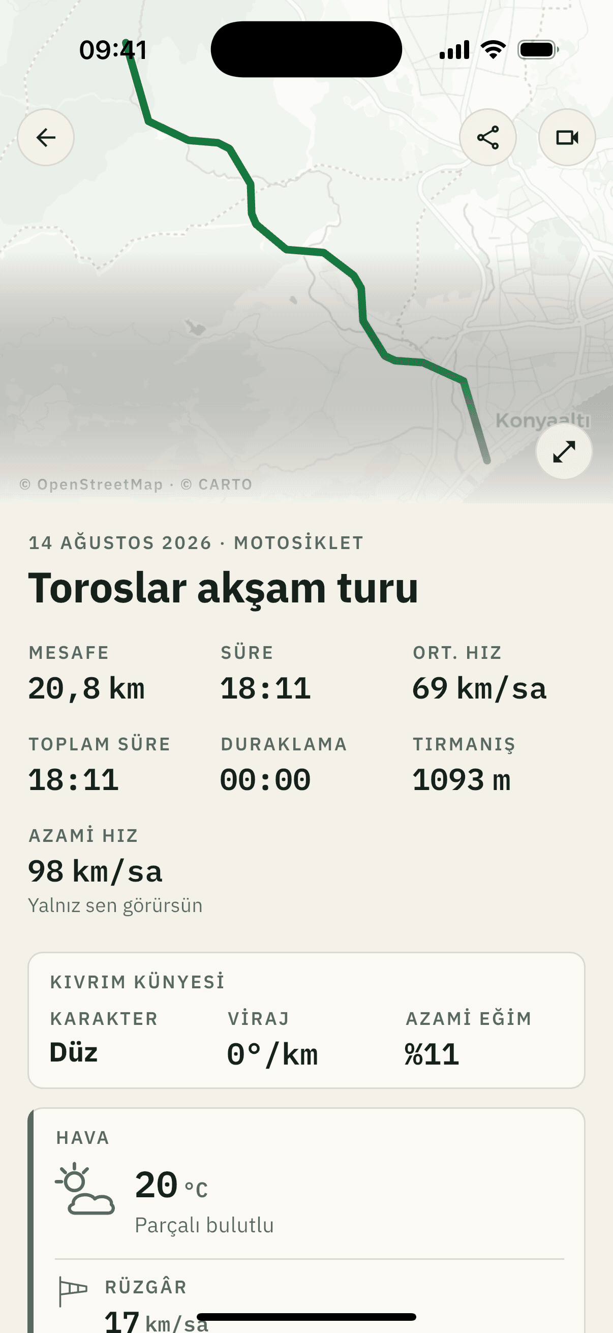
Bend record: 0°/km, straight — seeded trace, real arithmetic.
Ride record and map
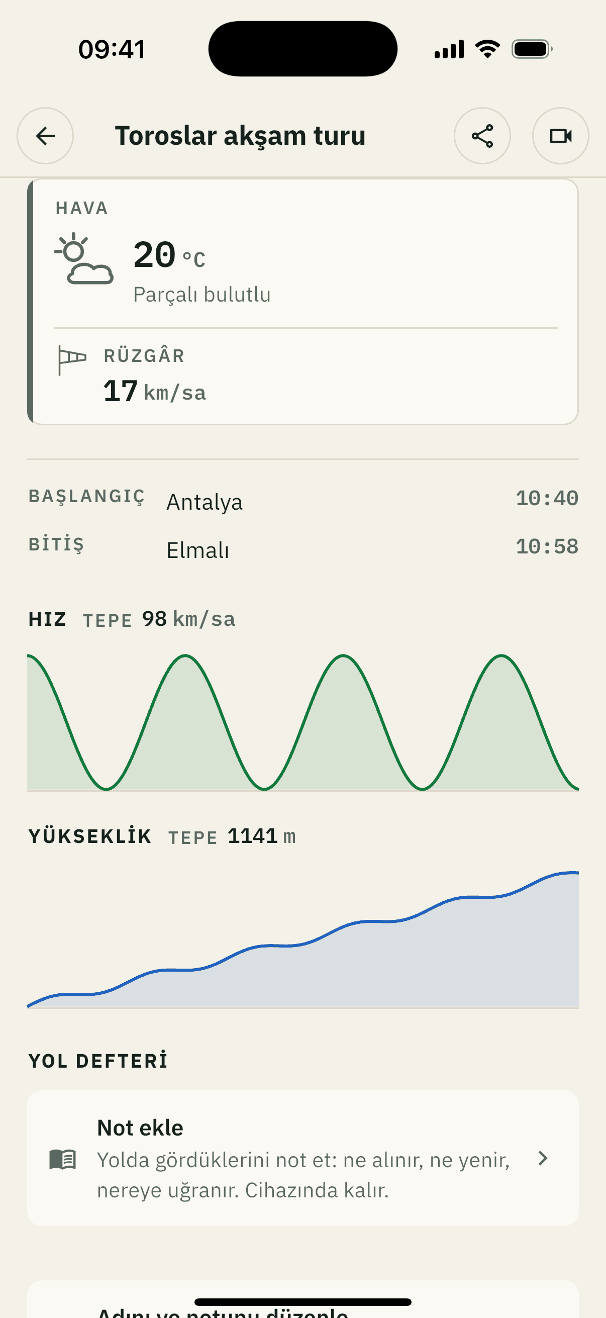
Weather is measured at the finish point.
Weather, profiles, road journal
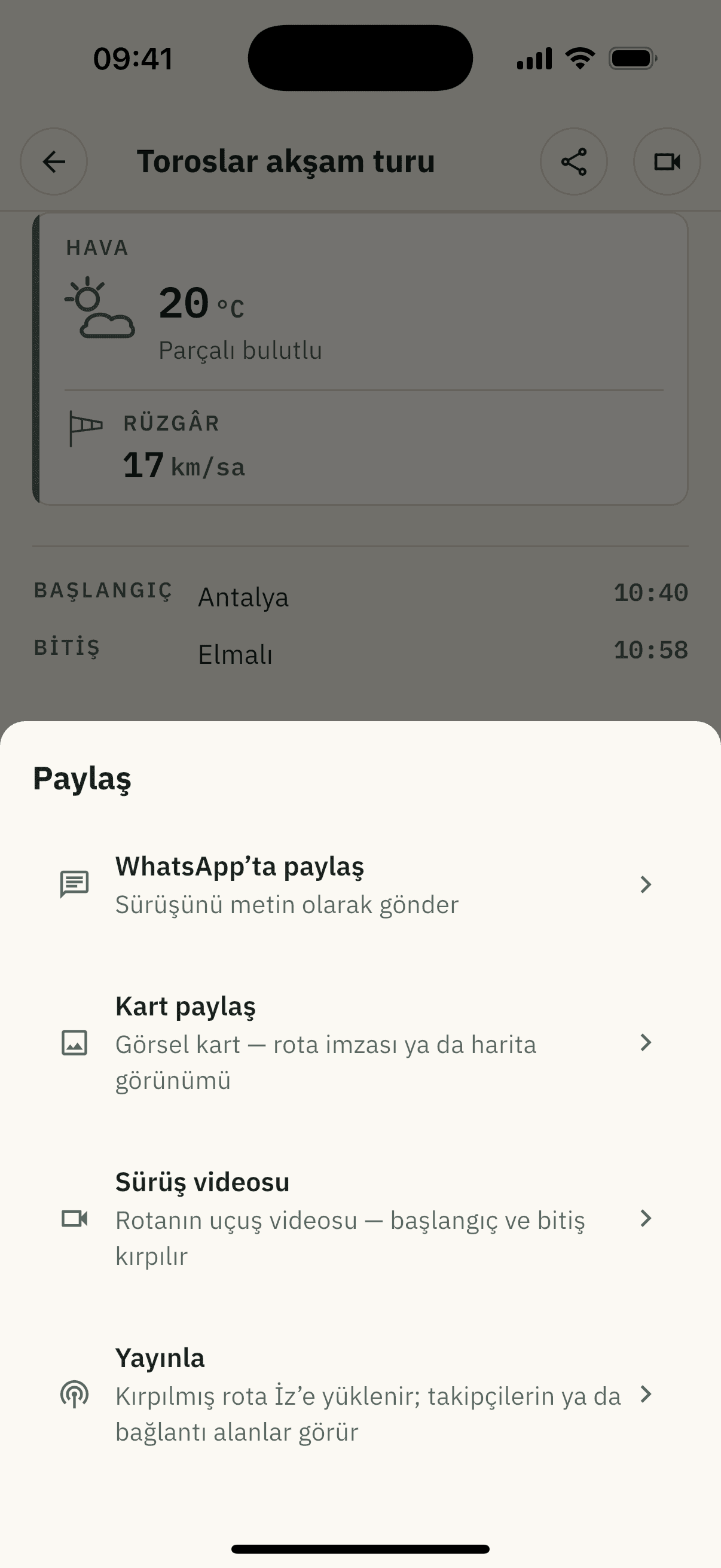
Share: card, video — nothing reaches the server.
Share — card, video, publish
All four come from the app itself, unretouched; the GPS trace in the frames was seeded for the shot. The publish button is written, but publishing is not open on the server side yet.
Frequently asked
Straight answers
Where do I download İz?
From Google Play or the App Store; both versions are live and free.
Who can see my rides?
Nobody, until you publish. When you do, the ends of the route are cut on the server: two radii, each drawn separately from between 400 and 700 metres, for every publication.
Are there speed records or rankings?
No, and there will not be. Nothing on a public road is ranked by time or speed. Even the route ribbon is coloured by smoothness rather than speed.
Does my route data reach my vehicle history?
No. Location and route data sit in a separate schema, outside the VIN-keyed data plane. Your plate, your VIN and your service records appear on no İz surface.
How is the bend record computed?
On the device, from the recording: a heading is taken every 50 metres, deviations under 8° are not counted, and the rest is divided by the total kilometres. Under 20°/km is straight, up to 80 flowing, up to 240 winding, above that very winding.
How do I start
You can start today.
İz is its own app, live on Google Play and on the App Store.
01
Download the app.
02
Record one journey.
03
If you like it, publish it.
04
If you don't, nobody sees it.
İz keeps routes and nothing else: plate, VIN and service records appear on no İz surface.
Content complaints
If a profile or a piece of content troubles you
- From inside the app — the button beside the profile, Report.
- Contact form — subject: “İz content complaint”↗ tr.
- Email — hukuk@t-iz.com, unlawful content included.
For the hosting-provider imprint and the complaint procedure, see Imprint↗ tr.
Links marked ↗ tr lead to Turkish-only pages.